Export
March 30, 2024
You can export your trip at any time from the Trip drawer. Click the export button and Furkot will create a copy of your trip plan in a selected file format and download it to your computer.
Before you export your trip, make sure it has no warnings: while some - like the warning about weekends - are merely informational, most are a sign that something is not quite right with your trip and the exported file may not be as you expect it.
Exporting trips in basic GPX format is offered to all users free of charge; selecting the file format and configuring the file content is a feature available exclusively to Furkot Pass holders.
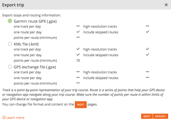
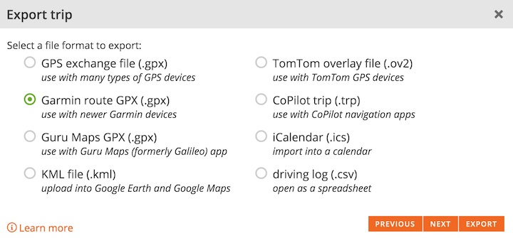
Furkot exports trip plans in following formats:
- GPS eXchange format (.gpx) files that can be used with many types of GPS devices. See the list of options described below
- KML files (.kml) that can be uploaded into Google Earth and Google Maps
- Files in proprietary formats supported by various GPS devices and navigation apps. Check the full list
- iCalendar (.ics) files that can be imported into calendar applications like iCal, Google Calendar, or Outlook
- Driving log as comma-separated values (.csv) that can be opened by most spreadsheet applications: Excel, Numbers, Calc, Google Docs etc. See the list of fields described below
- Expense report as comma-separated values (.csv) described below
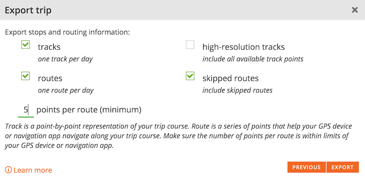
Every exported file regardless of a format will contain information about stops. Certain file formats support additional routing information in the form of routes and/or tracks. When exporting routing information, Furkot prepares one route and/or track for each day of the trip.
Track is a point-by-point representation of your trip course. Tracks always contain all points from your trip course. Tracks are best suited for displaying your trip on the map. Some GPS devices and navigation apps let you navigate along the track, but in most cases routes are better for navigation purposes.
Route is a series of points that helps your GPS device or navigation app navigate along your trip course. The number of points required to navigate along the same course as calculated by Furkot depends on the type of navigation (highway vs. off-road) and your GPS device or navigation app. Check your device/app limits and recommendations before you set it.
You can control the number of points per route and thus the degree to which exported routes trace the trip course as planned in Furkot. The route always contains all the stops for the day. It also contains all the pass-through points that anchor the trip course. Additionally the route is padded with additional points so that at least the specified number of points is included in each route. Many GPS devices limit the number of points per route: try exporting several versions of the route, with different values of the points per route specified, to strike a balance between the accuracy of your route and the limitations of your GPS device.
If the format supports it, routes and tracks will be named. By default, the route/track name is based on the day number and date. You can provide your own names for routes and/or tracks by creating day themes (labels). If the format supports it, day descriptions are also exported.
The exact steps required to transfer the exported file to a GPS device or a navigation app depend on the device or the app. If you need instructions for your GPS device consult its manual or contact its manufacturer support department: Garmin.
There are many navigation apps that can be used with Furkot. The few that we tested are listed here.
GPS eXchange format
GPX files are used by many GPS devices and navigation apps. When exporting a GPX file, Furkot always includes trip stops and skipped stops as waypoints. The exact content of routes and tracks in the exported GPX file depends on the export options.
| tracks | routes | |
|---|---|---|
| A single route with one routepoint for each trip stop and pass-through point. Additionally off-road segments are exported as separate tracks. | ||
| Series of tracks representing trip course. One track for each day | ||
| Series of routes based on trip course. One route for each day. The number of routepoints depends on the points per route value. | ||
| Series of tracks and routes representing trip course. One track and one route for each day. The number of routepoints depends on the points per route value. |
In addition to standard GPX format Furkot uses proprietary extensions to export your trip in a format better suited for selected GPS devices and navigation apps. Configuration of proprietary GPX format is a feature available exclusively to Furkot Pass holders.
Selecting the Garmin route GPX option will include stop addresses in a structured form supported by Garmin devices as well as assemble tracks within routes. Additionally, when Furkot exports waypoints corresponding to stops that have been tagged, the tags are exported as categories defined by the Garmin Extension Schema.
The Guru Maps GPX option will encode stop symbols and day colors in the format that Guru Maps navigation app can display.
Stop symbols
There is no established standard for symbols in the GPX files. Furkot encodes stop symbols in the proprietary format of Garmin, OsmAnd Maps, and Guru Maps depending on the GPX file selection.
Furkot uses Garmin proprietary names as well for generic GPX file format to offer some measure of interoperability.
Check out how Furkot stops translate to Garmin, OsmAnd Maps, and Guru Maps symbols.
Driving log
Furkot exports a driving log in CSV format setting character encoding to Unicode (UTF-8), using comma , as a delimiter to separate fields and enclosing each field in double quotes " (text delimiter). Not all spreadsheet applications assume those options automatically for the CSV file. When opening or importing the driving log into a spreadsheet application, you may need to set those options explicitly; otherwise the file may not be interpreted correctly.
The driving log exported from Furkot contains an entry for every route segment between stops with the following fields: From, From Address, To, To Address, Departure Date, Departure Time, Arrival Date, Arrival Time, Driving Time, Distance, Total Driving Time, Total Distance, Notes. The Total Driving Time and Total Distance denote cumulative time and distance from the beginning of the trip.
Expense report
The expense report is exported in CSV format setting character encoding to Unicode (UTF-8), using comma , as a delimiter to separate fields and enclosing each field in double quotes " (text delimiter). Not all spreadsheet applications assume those options automatically for the CSV file. When opening or importing the driving log into a spreadsheet application, you may need to set those options explicitly; otherwise the file may not be interpreted correctly.
Each expense is exported in a separate row containing date, expense type, amount, currency, and the stop tags to help with cost categorization.
Problem with export
When exporting a trip Furkot prepares the file and passes it to the browser for download. All modern browsers support downloading files. If you are having problems, visit WhatIsMyBrowser.com website to confirm that your browser is current and find a newer version if it is not.
Some browser add-ons and selected antivirus programs may examine downloaded files and even intercept and modify links on the page. That may prevent standard download functionality from working correctly. If, after clicking the Export button, Furkot displays the error page instead of exporting your trip, you need to determine what browser extension, add-on, or an antivirus program is interfering and reconfigure or disable it.

